 I am a master’s student in the Sea and Society master’s program at University of Gothenburg, Sweden, and I hold a master’s in computer science. Due to my technical background, I was very interested in the GIS and remote sensing internship that is offered at Archipelagos. I decided to spend my summer there and see what Archipelagos had to offer and how I could contribute.
The GIS team at Archipelagos has the incentive to carry out large projects, where the GIS interns, in loco, need to collaborate and work as a team rather than on individual tasks. I reached the island of Lipsi at the beginning of July, just after the Greek Covid-19 lockdown, and I spent almost my entire time with only one other GIS colleague, Patrick Flückiger from Switzerland.
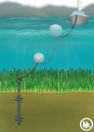
Ecological mooring project
 The project we mostly collaborated on is significantly important for the conservation of Posidonia Oceanica, an endemic plant of the Mediterranean Sea, well known for the wide range of ecosystem services that are beneficial for humans.
Among others anthropogenic impacts, Posidonia oceanica is threatened by the increasing number of leisure boats anchoring in rather shallow water (depth less than 40 meters), where the seagrass meadows are located. To avoid the damage of anchoring over Posidonia (which can contribute to unthinkable damage), Archipelagos is working on installing permanent and ecological mooring systems in several target bays of Lipsi island. Our task was therefore to provide very detailed maps showing the distribution of Posidonia oceanica and the bathymetry in such bays.

Patrick and I spent our first weeks performing data collection on the field. We made use of kayaks equipped with sonar technology to detect seagrass presence/absence. Since we needed very high accuracy, we did not make use of satellite images as current resolutions are not good enough. Therefore, we opted on designing very dense transects for the kayak, with less than 20 meters space between the lines, and we ran interpolation methods on the processed sonar data to generate our distribution maps. QGIS was used for all these purposes.
In order to obtain even more accurate maps, drone images can be used in combination with sonar data, by using image classification algorithms. Unfortunately, time limitations and a very windy summer forced us to postpone this idea.
Data analysis on python
 At Archipelagos, there are always side projects going on. One that is worth mentioning is our involvement in moving the analysis of geographical and sonar data into python, a modern and dynamic programming language. Today, each of the aforementioned steps is performed manually with the use of computer tools. Python would enable us to process all data and generate maps by exclusively running our scripts. My contribution on this was to create a Python Notebook to automatically decode the sonar binary files and to generate plots showing the recorded bouncing data, which are used to detect Posidonia presence/absence. Scripts such as this one can drastically reduce the time needed for processing data and remove the bias derived by the personal interpretation of presence/absence coming from manual analysis.
In conclusion, from a GIS team perspective, Archipelagos gave us the opportunity to contribute to a project in its entirety, from data collection and analysis to conclusions, with the possibility to use gears and equipment, such as the sonar, and with a well prepared supervisor.
Corrado Motta
MSc student, Sea & Society at University of Gothenburg, Sweden,
On-site intern at the GIS team of Archipelagos Institute