Archipelagos

  • English
  • Ελληνικα
Ποιοί Eίμαστε
Το ΑρχιπέλαγοςΤο Αρχιπέλαγος
Ποιοί ΕίμαστεΠοιοί Είμαστε
Ερευνητικές ΒάσειςΕρευνητικές Βάσεις
Ερευνητικά ΣκάφηΕρευνητικά Σκάφη
ΕξοπλισμόςΕξοπλισμός
ΣυνεργάτεςΣυνεργάτες
ΥποστηρικτέςΥποστηρικτές
Πεδία Δράσης
Θαλάσσια ΠροστασίαΘαλάσσια Προστασία Αλιεία Kίνδυνος Θαλάσσιου Ατυχήματος Λιβάδια Ποσειδωνίας Παράκτια Οικοσυστήματα Θαλάσσιες Χελώνες
Θαλάσσια ΘηλαστικάΘαλάσσια Θηλαστικά Δελφίνια Φάλαινες Φώκιες
Χερσαία ΠροστασίαΧερσαία Προστασία Νησιωτική Πανίδα Δάση και Χλωρίδα Οικοσυστήματα Εσωτερικών Υδάτων Κιβωτός Σπόρων Αιγαίου
Εργαστηριακή ΈρευναΕργαστηριακή Έρευνα Μικροπλαστικά Ποιότητα Νερού Ποιότητα Εδάφους
Projects
Καταφύγιο Θαλάσσιας Ζωής Αιγαίου
Ημερολόγιο Εργασίας
Save the Aegean
Υλικό
Υλικό Ευαισθητοποίησης
Videos
Δημοσιεύσεις
Συμμετοχή
Internships
Remote Internships
Καλοκαιρινό Σχολείο
Ημερολόγιο Εργασίας
Νέα
Sea Diamond – Εγκαταλελειμμένο Τοξικό Απόβλητο επί 14 χρόνια στον βυθό της Σαντορίνης
2 Δια-νησιωτικές Διακομιδές Ασθενών με σκάφος του Ινστιτούτου Αρχιπέλαγος
Χαρτογράφηση των θαλάσσιων λιβαδιών Ποσειδωνίας και παράκτιων οικοτόπων με τη χρήση καγιάκ
Οι Mαθητές Αναλαμβάνουν Δράση
Προβολή όλων...
Επικοινωνία
Δωρεά
Menu

GIS Mapping as a Key Tool in Marine Conservation

GIS Mapping as a Key Tool in Marine Conservation

by Kleopatra Delaveri / Τετάρτη, 31 Ιουλίου 2019 / Published in Intern Experience, Ημερολόγιο Εργασίας, Ομάδα GIS

Inge joined the Archipelagos GIS team in April 2019 for a research internship to complete her Master’s degree in Geographical Information Management and Application at the University of Utrecht, in the Netherlands. She uses spatial data and geo-information as a key tool in providing answers to complex issues concerning the conservation of our environment, since spatial analysis is able to provide a better understanding of habitats and species.

Her main project is the mapping of Posidonia Oceanica seagrass meadows,in order to protect these valuable marine ecosystems from degradation mainly caused by anthropogenic impacts. The GIS team combines Geographical Information Systems (GIS) with the processing of satellite imagery to derive information about the locations of these seagrass meadows. Distribution models, including habitats, species and vulnerability, are the final output of their work. Inge, specifically, focuses on the technical methodology of the classification of the satellite imagery, with the overarching goal of optimizing the method to improve the accuracy.

The Regional Activity Centre for Specially Protected Areas (SPARAC) is a major player in the seagrass project. Archipelagos carries out extensive research to map the distribution of P. Oceanicaaround nine islands in the Southeast Aegean Sea. Inge played an important role in this research by collecting data in the field and modeling this data into useful information. Several of her maps have been used in the final report for SPARAC.

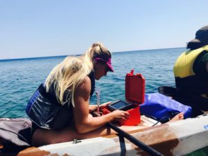
The data that is used in this research is often obtained by means of surveys at sea using Archipelagos’ research vessels. Inge is frequently aboard the Aegean Explorer collecting data. The combination of technical GIS work with the practical and physical endeavor that comes with living and working on a boat is a new experience that she fully enjoys. During the trips, the team is dropped off at the coast of islands in the Southeast Aegean Sea to perform measurements by means of kayak surveys. A single beam sonar is installed on the back of the kayak to measure the seafloor and detect seagrass. Later on in the process, this data is used in different software solutions to create the final distribution models.

Since geo-information is a broad concept and very useful to a wide range of disciplines, Inge is a big help to multiple projects within the different Archipelagos’ teams. The environmental data that is collected during surveys need to be mapped and analyzed in more detail in order to achieve effective environmental preservation in the Eastern Aegean Islands. For example, Inge contributed to the Archipelagos jackal team by making overview maps displaying the locations of their camera traps; she processed data about seabird species in GIS to explicit maps and, in addition, she mapped the brackish water pond where various important species live, including terrapins and endangered eels. The maps that Inge creates are used by many colleagues in their reports.

In addition to all the practically acquired knowledge, Inge learned a lot about herself, different cultures and life in general by working and living together with students and staff from all over the world. Reflecting on her internship she says: ‘I feel very honored being part of such an inspiring and hardworking team that is committed to what they admire the most: the marine life. It makes me proud that our crew originates from more than 30 different countries, who all have travelled to Greece to share their knowledge and skills for marine conservation’.
0
0
0
0
0

Σχετικά άρθρα

Using GIS and Remote Sensing for Conservation
Distribution Model for Common Dolphins near the Island of Samos
Microplastics Research at Archipelagos

HIGHLIGHTS

  • Απονομή του Βραβείου Ευκράντη στο Ινστιτούτο Θαλάσσιας Προστασίας Αρχιπέλαγος

    Απονομή του Βραβείου Ευκράντη στο Ινστιτούτο Θαλάσσιας Προστασίας Αρχιπέλαγος

    27 Ιουλίου 2020
    Ιδιαίτερη τιμή και ηθική στήριξη για όλους όσους απαρτίζουν το …
  • Επίσκεψη της Προέδρου της Δημοκρατίας στο σκάφος Aegean Explorer του Ινστιτούτου Θαλάσσιας Προστασίας «Αρχιπέλαγος»

    Επίσκεψη της Προέδρου της Δημοκρατίας στο σκάφος Aegean Explorer του Ινστιτούτου Θαλάσσιας Προστασίας «Αρχιπέλαγος»

    30 Ιουνίου 2020
    Στο πλαίσιο της χθεσινής επίσκεψης της Πρόεδρου της Δημοκρατίας στο …
  • Παρουσίαση ταινίας για το Καταφύγιο Θαλάσσιας Ζωής Αιγαίου

    Παρουσίαση ταινίας για το Καταφύγιο Θαλάσσιας Ζωής Αιγαίου

    11 Φεβρουαρίου 2020
    Στις 14 Φεβρουαρίου στο πλαίσιο του World Whale Film Festival, …
  • Βράβευση απένειμε προς στο Ινστιτούτο Αρχιπέλαγος το International Propeller Club of the United States

    Βράβευση απένειμε προς στο Ινστιτούτο Αρχιπέλαγος το International Propeller Club of the United States

    6 Φεβρουαρίου 2020
    Θα θέλαμε να ευχαριστήσουμε το International Propeller Club of the …

Πρόσφατα Άρθρα

  • Sea Diamond – Εγκαταλελειμμένο Τοξικό Απόβλητο επί 14 χρόνια στον βυθό της Σαντορίνης

    Sea Diamond – Εγκαταλελειμμένο Τοξικό Απόβλητο επί 14 χρόνια στον βυθό της Σαντορίνης

    13 Απριλίου 2021
    14 χρόνια μετά την βύθιση και εγκατάλειψη του Sea Diamond, που στοίχισε …
  • 2 Δια-νησιωτικές Διακομιδές Ασθενών με σκάφος του Ινστιτούτου Αρχιπέλαγος

    2 Δια-νησιωτικές Διακομιδές Ασθενών με σκάφος του Ινστιτούτου Αρχιπέλαγος

    7 Απριλίου 2021
    Παρά τις δυσμενείς καιρικές συνθήκες που επικρατούν στο Αιγαίο, το …
  • Χαρτογράφηση των θαλάσσιων λιβαδιών Ποσειδωνίας και παράκτιων οικοτόπων με τη χρήση καγιάκ

    Χαρτογράφηση των θαλάσσιων λιβαδιών Ποσειδωνίας και παράκτιων οικοτόπων με τη χρήση καγιάκ

    29 Μαρτίου 2021
    Παρ’όλες τις δύσκολες συνθήκες, στο Ινστιτούτο Αρχιπέλαγος προσαρμόζουμε, σύμφωνα με …
  • Οι Mαθητές Αναλαμβάνουν Δράση

    Οι Mαθητές Αναλαμβάνουν Δράση

    4 Μαρτίου 2021
    Προσαρμοζόμενοι στις ιδιαίτερες συνθήκες της εποχής το Ινστιτούτο Αρχιπέλαγος συνεχίζει …
  • Διαδικτυακό Μάθημα για την Προστασία του Αιγαίου, με το 8ο Νηπιαγωγείο Καλύμνου

    Διαδικτυακό Μάθημα για την Προστασία του Αιγαίου, με το 8ο Νηπιαγωγείο Καλύμνου

    15 Φεβρουαρίου 2021
    Από όλους τους μαθητές και φοιτητές που συμμετέχουν στα μαθήματα …
  • 4 Νέα Εργαστήρια – Παρατηρητήρια Κλιματικής Αλλαγής και Πλαστικής Ρύπανσης πρόκειται να δημιουργηθούν στην Ινδία και την Μαλαισία

    4 Νέα Εργαστήρια – Παρατηρητήρια Κλιματικής Αλλαγής και Πλαστικής Ρύπανσης πρόκειται να δημιουργηθούν στην Ινδία και την Μαλαισία

    12 Φεβρουαρίου 2021
    Αυτή η σημαντική δράση ξεκίνησε την προηγούμενη εβδομάδα έπειτα από …
  • O «Aegean Explorer» στη Μάχη για την Προστασία των Θαλασσών μας

    O «Aegean Explorer» στη Μάχη για την Προστασία των Θαλασσών μας

    9 Φεβρουαρίου 2021
    Καθώς η επιβάρυνση που προκαλεί ο άνθρωπος στις θάλασσες μας …
  • English
  • Ελληνικα

Εγγραφή στο newsletter μας

Το Αρχιπέλαγος στοχεύει στην μελέτη και προστασία της ιδιαίτερης βιοποικιλότητας των ελληνικών θαλασσών και νησιών.

Οι δράσεις μας θα ήταν αδύνατο να πραγματοποιηθούν χωρίς εσάς!

donate
  • Όροι και Προϋποθέσεις
  • Τρόποι Πληρωμής
  • Πολιτική Επιστροφών / Ακυρώσεων

Archipelagos - Institute of Marine Conservation © All Rights Reserved || Web Design and Development by Red Web Design & Fekas Brothers

TOP