Despite the difficult conditions, at the Archipelago Institute we adapt our actions to protect the biodiversity of our seas according to the restrictions. Researchers in the Geographic Information Systems (GIS) team of the Archipelago Institute, continue to map the Posidonia seagrass meadows and the coastal habitats using kayaks.
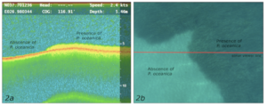
In collaboration with the British University of West of England Bristol we have developed a pioneering methodology for mapping Posidonia seagrass meadows using kayaks equipped with portable sonars. The data collected in combination with data from drones and satellite images are used to create detailed maps depicting marine habitats and the distribution of underwater meadows.

Having developed all the relevant codes and protocols of this methodology and having developed the software used, the Archipelagos Institute’s methodology has been awarded internationally for its efficiency and validity as well as its low cost. It has already been used to train scientists from North African countries in collaboration with the United Nations Regional Action Center for the Mediterranean (UNEP / MAP – SPA / RAC), while each year the Archipelago Institute trains a large number of young scientists from top universities of Europe and the world in this technique.
Without detailed maps to show the exact location and extent of seagrass meadows, it is impossible to implement the existing legislation for its protection. Through their work, the researchers of the Archipelago Institute are trying to bridge numerous gaps, in order to protect the “forests” of our seas before it is too late.

